
Louisiana Purchase: The Story of the Largest Land Deal in History
The Louisiana Purchase was one of the largest land deals in history, concluded by the United States with Napoleonic France in 1803.
The United States purchased 828,000 square miles (2,140,000 km²) for $15 million, or about $18 per square mile, which was considered the greatest achievement of then-US President Thomas Jefferson.
The Kingdom of France controlled the Louisiana Territory from 1699 until 1762, when it was ceded to Spain. In 1800, Napoleon, the First Consul of the French Republic, regained ownership of Louisiana as part of a broader project to re-establish a French colonial empire in North America.
At that time, the area of the French colony on American soil was estimated at more than two million square kilometers (Louisiana lands). Meanwhile, the United States attempted to buy the New Orleans area, which was part of French Louisiana, for $10 million from the French, due to its economic and strategic importance. However, the American demands were categorically rejected by France.
But France’s failure to suppress a revolt in Saint-Domingue, along with the likelihood of renewed war with the United Kingdom, led Napoleon to consider selling Louisiana to the United States.
Acquiring Louisiana had been a long-term goal for President Thomas Jefferson, who particularly sought control of the vital port of New Orleans on the Mississippi River.
Jefferson tasked James Monroe and Robert R. Livingston with purchasing New Orleans. Negotiating with French Treasury Minister François Barbé-Marbois (who acted on behalf of Napoleon), the American representatives quickly agreed to purchase the entire Louisiana Territory after it was offered. Overcoming opposition from the Federalist Party, Jefferson and Secretary of State James Madison convinced Congress to approve and fund the Louisiana Purchase.
Significance of the Louisiana Purchase
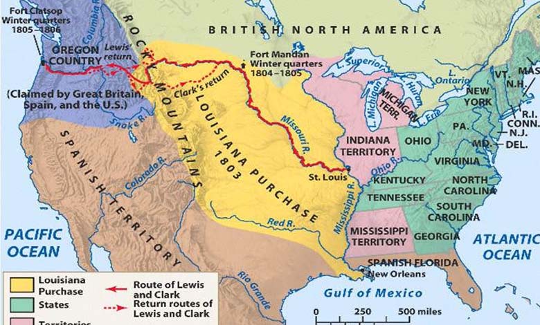
The Louisiana Purchase helped expand US sovereignty across the Mississippi River, nearly doubling the nominal size of the country. The deal included lands in 15 current US states and two Canadian provinces, including all of Arkansas, Missouri, Iowa, Oklahoma, Kansas, and Nebraska; large portions of North Dakota and South Dakota; parts of Montana, Wyoming, and Colorado east of the Continental Divide; the part of Minnesota west of the Mississippi River; the northeastern part of New Mexico; the northern parts of Texas; New Orleans and the parts of current Louisiana west of the Mississippi River; and small portions within Alberta and Saskatchewan.
-
Washington loses its strategic base for monitoring the coast and Libya with the withdrawal from Niger
-
Title: Provocative Step Allows Russian Soldiers to Enter US Base in Niger
At the time of the purchase, the non-native population of Louisiana was about 60,000 people, half of whom were “African slaves.” The western borders of the purchase were later settled by the Adams-Onís Treaty with Spain in 1819, while the northern borders were adjusted by the 1818 treaty with Britain.