
Hundreds of Millions at Risk: Study Maps ‘Destruction’ in America
The United States Geological Survey has revealed that its team expects nearly 75% of the United States to be susceptible to a devastating earthquake due to the presence of around 500 faults.
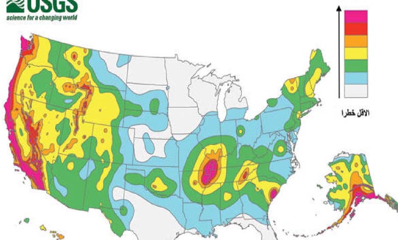
Led by the United States Geological Survey, a team comprising over 50 scientists and engineers created a model to establish a color-coded map identifying locations where destructive earthquakes are likely to occur. This model is based on seismic studies, historical geological data, and the latest data collection techniques.
The updated model by the United States Geological Survey (NSHM), requested by Congress, serves as a crucial tool to help engineers and others mitigate the impact of earthquakes on vulnerable communities by highlighting potential earthquake locations and the extent of potential shaking.
The new research, published in the journal Earthquake Spectra, identified nearly 500 additional faults that could lead to a destructive earthquake.
Mark Petersen, a geophysics scientist at the United States Geological Survey and the lead author of the study, said, “This has been a massive collaborative effort for several years involving federal, state, and local governments, as well as the private sector, and the new seismic risk model represents a significant achievement for enhancing public safety.”
Noteworthy changes in the new model show the possibility of more destructive earthquakes along the Mid-Atlantic and Northeastern coastal corridor, including cities like Washington D.C., Philadelphia, New York, and Boston.
Additionally, there is a chance for further shaking in earthquake-prone regions in California and Alaska. The new model also describes Hawaii as having a higher potential for shaking due to recent volcanic eruptions and seismic disturbances on the islands.
Petersen stated, “Predicting earthquakes is challenging, but we have taken significant steps with this new model, which includes more faults, better-characterized ground surfaces, and computational advancements in modeling that provide the most detailed insight ever into the earthquake risks we face.”
The main findings from the updated seismic risk model include:
- Risks to Individuals: Nearly 75% of the United States could experience destructive earthquakes and intense ground shaking, exposing hundreds of millions of people to danger.
- Broad Risk: 37 U.S. states have experienced earthquakes exceeding a magnitude of 5 in the past 200 years, highlighting a long history of seismic activity throughout the country.
- Structural Impacts: The updated model provides crucial insights for architects and policymakers on how to plan and construct buildings across the United States.
- Unified Approach: This is the first national seismic risk model covering all fifty states simultaneously, reflecting a massive collaborative effort with federal, state, and local partners.