
A Strange Phenomenon Accompanies Hurricane “Milton”… What Is Reverse Surge?
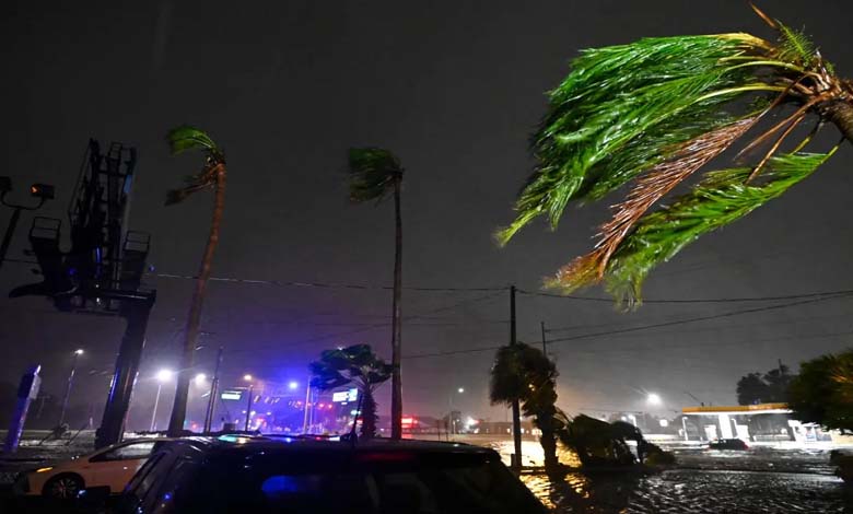
Hurricane “Milton,” which struck the state of Florida, was accompanied by a strange event. While observers were concerned that up to 4.5 meters of water could be pushed onto the densely populated coasts of Tampa Bay, water levels in the city temporarily dropped by several feet as the hurricane passed. What happened?
-
Worst in 100 years: Florida braces for Hurricane Milton
-
Hurricane Milton: A Terrifying Scenario Looms Over Florida
Reverse Surge
The scientific explanation for this phenomenon, according to the Associated Press, is called “reverse storm surge.” It is a well-known occurrence during hurricanes, though it is sometimes difficult to observe. This phenomenon is related to the way hurricane winds move seawater when storms make landfall, as was the case in Tampa Bay.
In the northern hemisphere, the winds of tropical storms blow counterclockwise. Upon reaching land, the rotating winds push water toward the shore on one side of the “eye of the storm” and pull it away from the shore on the other side.
-
Hurricane Helene Claims Over 200 Lives in the United States
-
All Bridges Destroyed: Hurricane Helene Isolates a Remote Area in North Carolina
Brian McNoldy, a tropical storm researcher at the University of Miami, explained that the most noticeable water movement occurs beneath the strong winds of the storm’s eyewall.
The path of Hurricane “Milton” toward the central part of Florida’s west coast had been clear for several days, increasing the likelihood that Tampa’s coastline would bear the brunt of flooding. However, it is always difficult to predict exactly where and when a hurricane will make landfall, which is crucial because the daily high tide can amplify the force of water surges.
-
Hurricane “John” leaves 16 dead in Mexico
-
Hurricane “Helene”: Strong Winds and Powerful Storms Headed Towards Florida
Sudden Drop in Water Levels
Certainly, winds, rains, and floods can be intense far from the storm’s center, but the exact point of landfall greatly impacts where the “water surge” will peak, as McNoldy pointed out. The same applies to reverse or “negative” surge.
Eventually, the center of Hurricane “Milton” made landfall Wednesday evening in the Siesta Key area, near Sarasota, approximately 112 kilometers south of Tampa.
-
With fierce winds, Hurricane “Francine” strikes the US state of Louisiana
-
“Climate Change” Affects the Intensity of Rainfall and Hurricanes
This means that strong offshore winds caused a significant water surge south of Siesta Key. According to the National Hurricane Center, preliminary data indicated that water levels in that area rose by about three meters, while water levels near Tampa suddenly dropped by about five feet.
The senior researcher in tropical storms at the University of Miami recalled similar effects from previous hurricanes, including Hurricane “Irma” in 2017 and Hurricane “Ian” in 2022.
-
Hurricane “Beryl” Sweeps Through Jamaica, Causing Massive Destruction and Casualties
-
“Beryl” Becomes a “Potentially Catastrophic” Category 5 Hurricane
In any storm, McNoldy explained, “It’s a very bad idea because the water will come back.” And indeed, water levels returned to normal in Tampa by Thursday morning.