Africa Becomes Bigger on Maps Thanks to a UN Decision!
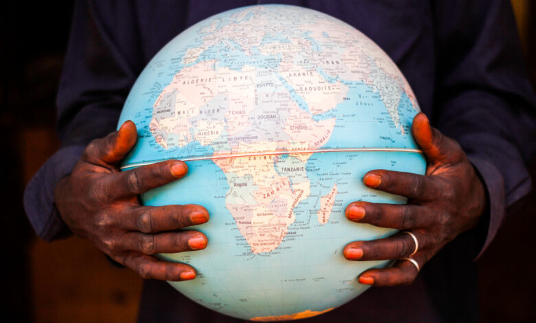
The United Nations General Assembly overwhelmingly backed a resolution proposed by Togo, while the African Union has recommended the adoption of more accurate map projections that better reflect the true size of continents and correct the visual distortion of Africa’s area caused by the Mercator projection.
-
A Neo-Colonial Tool of Repression: Three African Countries Withdraw from the International Criminal Court
-
African Union Forces Helicopter Crashes in Somalia
The United Nations General Assembly overwhelmingly approved a resolution on Friday calling for a more accurate cartographic representation of the relative sizes of the world’s continents. The initiative, led by Togo and the African Union, is aimed in particular at correcting the visual representation of Africa, which appears significantly smaller than its actual size on the world maps most commonly used.
A total of 164 countries voted in favour of the resolution, while only one country—the United States—voted against it. Six countries abstained.
The resolution is not legally binding. It does not prohibit the use of the Mercator projection, nor does it impose a single map on countries around the world. However, it encourages governments, schools, institutions and digital platforms to use map projections that more accurately preserve the true proportions of continental land areas.
-
ISIS in Somalia strengthens its influence and becomes a global logistical hub for the organization… How?
-
Washington and Puntland: Security Deal Expands U.S. Presence at the Gateway to the Red Sea
The resolution, entitled “Correcting the Map: Rebalancing Global Cartographic Representation and Promoting the Fair Representation of the World’s Regions, Particularly Africa,” specifically encourages the use of the Equal Earth projection, designed in 2018 by cartographers Tom Patterson, Bojan Šavrič and Bernhard Jenny to represent the areas of continents in proportions that more closely reflect reality.
The issue dates back to the Mercator projection, developed in 1569 by the Flemish cartographer Gerardus Mercator.
It was originally designed primarily for maritime navigation because it preserves directions and angles. However, it visually enlarges regions located near the poles while relatively reducing the apparent size of areas near the equator.
-
Accusations of Targeting Civilians with Military Airstrikes in Sudan: The Sky of War over North Kordofan
-
Terrorism Worsens Hunger… Boko Haram and ISIS Turn Lake Chad into a Graveyard
The effect is particularly clear when Africa is compared with Greenland. On Mercator maps, the two appear relatively similar in size, whereas Africa is in reality approximately fourteen times larger than Greenland. Europe, Russia, Canada and parts of North America also appear relatively larger than they actually are, while Africa, South America and other tropical regions appear smaller.
This does not mean that the Mercator projection is an “incorrect map.” It remains highly useful for navigation.
However, its critics argue that a projection originally designed for maritime purposes has become widely used as a general representation of the world and in education, where comparing the actual sizes of countries and continents is far more important. Cartographic experts also stress that there is no perfect flat representation of the spherical Earth, as every projection must sacrifice some degree of accuracy in relation to shape, area, distance or direction.
-
Shifts in the Relationship Between Khartoum and Addis Ababa Amid a Potential Rapprochement with Tigray
-
From bombs to algorithms: ISIS weaponises artificial intelligence
Togo led the campaign at the United Nations on behalf of the African Union as part of the “Correct the Map” initiative, which seeks to address what African countries consider a cartographic legacy that reinforces unbalanced perceptions of the world.
The campaign argues that maps do not merely reflect geography; they also influence how people perceive the importance of regions and continents. Supporters of the initiative have used the term “cartographic colonialism” to describe the visual legacy of certain traditional maps.
Lomé is scheduled to host a meeting in the first quarter of 2027 bringing together the African Union, UNESCO, and technology and mapping companies to discuss the implementation of the initiative.
The U.S. position was one of the most notable surprises of the vote.
-
A new blow to ISIS in Puntland… Arrest of the logistics and communications chief
-
Nigeria and the repentant terrorists… a journey back from extremism
By contrast, the United Kingdom, several European countries and the African Union supported the resolution. France announced on the same day that it would adopt the Eckert IV projection for its official maps instead of the Mercator projection. Eckert IV is also an equal-area projection, although it differs from the Equal Earth projection.
India also supported the resolution but clarified that its vote did not mean it was exclusively adopting Equal Earth. Rather, it expressed support for the use of equal-area projections more broadly.
Estonia, Georgia, Lithuania, Moldova, Serbia and Ukraine abstained, highlighting how cartographic issues can also intersect with sensitive political and sovereignty-related questions.
-
How extremist groups hide their crimes behind quotes from philosophers and online thinkers
-
Gen Z from the Andes to the Himalayas: Leaderless Voices under the Skull Banner
The resolution does not seek to eliminate the Mercator projection from navigation. Instead, it aims to change its use as the standard image of the world in education, the media, institutions and digital platforms.
Togo is particularly seeking to involve mapping and technology companies in the next phase of the initiative, which could open a broader debate about how digital mapping services represent the relative sizes of the world’s continents.
-
Somalia: A presidential roadmap amid warnings of collapsing UN support
-
Sudan Between the Hammer of Its Crises and the Anvil of Turkish Influence
-
Egypt and the Muslim Brotherhood: Talha’s Release Exposes Double Standards and Threatens Regional Security
-
Somali Woman Sentenced to Prison and Deportation in U.S. for Fraud and Concealing Terrorist Ties