Morocco Harnesses Artificial Intelligence to Anticipate Floods
Moroccan innovators have successfully developed a satellite-based system capable of predicting flood-prone areas with an accuracy rate of 91 percent, enabling the country to shift from reactive crisis management to proactive prevention.
Morocco has begun implementing artificial intelligence technologies to forecast the most dangerous floods and prepare for them in advance. The Spanish newspaper El Español described this initiative as a valuable lesson for neighboring Spain on how to manage natural disasters effectively.
-
Morocco Consolidates the Realism of the Solution: The UN Security Council Resolution Marks a Turning Point in the Moroccan Sahara Issue
-
From Backroom Diplomacy to the Voting Floor: How Morocco Won the UN Security Council Battle Over the Moroccan Sahara
In a report by journalist Roberto Méndez published on June 5, 2026, the newspaper emphasized that artificial intelligence is no longer merely a passing technological trend but has become a critical tool for improving the accuracy of predictions of extreme weather events and reducing their impact.
This approach comes as Morocco undergoes a strategic transformation in the management of its resources and natural crises, while simultaneously cooperating with Spain to combat drought through the construction of Africa’s largest desalination plant.
-
From New York to Laayoune: How Moroccan Diplomacy Worked Behind the Scenes to Secure the UN Vote for Autonomy
-
The UN Security Council supports Morocco’s autonomy plan for Moroccan Sahara
From Response to Prevention
Wildfires, earthquakes, and floods are among the natural disasters that cause immense human and economic losses, and their frequency continues to increase year after year.
As climate change accelerates and intensifies episodes of heavy rainfall, the number of people living in vulnerable and high-risk areas is also rising.
Within this context, experts argue that the relevant question is no longer whether floods will occur, but rather where and when they will happen.
-
Visit of the U.S. Congress to the Moroccan Sahara: A Strategic Reading of Regional and International Dimensions
-
Widespread Rejection of Misrepresentations in UN Security Council Report on the Moroccan Sahara
While many countries continue to adopt reactive policies after floodwaters have already inundated streets and homes, Morocco has fundamentally changed its approach by moving toward proactive prevention through artificial intelligence, similar to Google’s Groundsource system, which is designed to predict floods up to twenty-four hours in advance.
A research team from Abdelmalek Essaâdi University and Mohammed V University developed an artificial intelligence system capable of identifying the areas most vulnerable to flooding within the Loukkos River basin in northern Morocco.
-
U.S. Support for Moroccan Sovereignty over the Sahara: A Consistent Strategic Choice
-
Larcher’s Visit to the Moroccan Sahara Reflects France’s Interest in Strengthening Cooperation with Rabat
The study focused on one of the regions most exposed to flooding: the plain located between the cities of Ksar El Kebir and Larache. This area combines extremely low-lying terrain, proximity to the river, intensive agricultural activity, and frequent exposure to severe winter storms.
The project’s innovative aspect lies in combining imagery from the European Sentinel satellite program with machine-learning algorithms.
The system did not rely solely on historical records. Researchers also employed advanced space-based radar systems capable of detecting flooded areas even through dense cloud cover.
Using these datasets, the team created a detailed map of areas affected by previous floods and used it to train artificial intelligence models.
-
“Shared Destiny” Presents a New Vision for Moroccan-French Relations
-
Legality of Moroccan Military Maneuvers Ends Controversy Raised by the Canary Islands
The algorithms learned to identify the topographical and geographical characteristics that contribute to flooding. Multiple variables were analyzed, including elevation above sea level, terrain slope, distance from rivers, drainage network density, water accumulation potential, and rainfall patterns. Based on these factors, highly detailed maps were produced, classifying territories according to their flood-risk levels.
High Accuracy and a Real-World Test in 2026
Although the system does not provide real-time flood forecasts, its results proved highly impressive. The models accurately identified the most vulnerable areas, particularly the plains located near the Loukkos River.
-
Algeria burdens suppliers with a hostile decision that prohibits them from dealing with Moroccan ports
-
The Moroccan diplomacy undermines Algerian plots in the African Parliament
The most effective model, an artificial neural network known as a Multilayer Perceptron, achieved an accuracy rate of 91 percent when tested on new data that had not previously been processed.
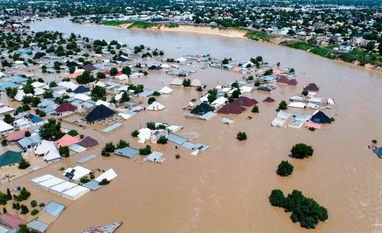
The technology’s real-world validation came shortly afterward. Between January and February 2026, the region experienced one of its most severe floods in decades.
Prolonged heavy rainfall, river overflow, and controlled water releases from upstream dams caused significant damage and forced authorities to evacuate thousands of residents.
-
U.S. moves to expedite resolution of the fabricated conflict in the Moroccan Sahara
-
Steadfast Gulf Position on the Moroccan Sahara
Satellite images captured after the disaster revealed that the flooded areas closely matched the zones previously classified by the artificial intelligence system as being at “high” or “very high” risk.
This correspondence provides compelling practical evidence of the remarkable capabilities of these intelligent models. Rather than attempting to predict the future in a speculative manner, they enable authorities to identify risks and vulnerabilities well before the next storm arrives and to take appropriate preventive measures.
A Lesson for Spanish Planners
El Español concluded that Morocco’s experience offers highly valuable lessons for Spain, recalling the devastating floods caused in recent years by the DANA weather phenomenon, particularly in regions such as Valencia.
-
Intensive Moroccan diplomatic movement with the appointment of new ambassadors in influential capitals
-
Moroccans remember the 1960 disaster… What’s its connection to the Marrakech Earthquake?
While University of A Coruña is currently exploring the use of artificial intelligence for flood prediction, the newspaper argues that Spain still has significant room for improvement in systematically integrating artificial intelligence, satellite monitoring, and Geographic Information Systems (GIS) into urban planning and land management.
Having precise knowledge of the residential neighborhoods, infrastructure, and agricultural areas most vulnerable to flooding would enable governments to prioritize investments more effectively, improve evacuation plans, and avoid construction in high-risk zones.
In short, artificial intelligence has the potential to accelerate the transition from a reactive strategy toward a genuinely preventive one, especially since the data required to achieve this transformation is now widely available.
-
Austria supports Moroccan sovereignty over Western Sahara in new Moroccan diplomatic victory
-
Sánchez: “The Moroccan initiative is the most serious basis for solving the Sahara conflict”